

Geographical location
The Canary Islands form an archipelago situated off the north-western coast
of Africa, near the territories of Western Sahara and Morocco, between 27–29
degrees north latitude and 13–18 degrees west longitude.
It comprises seven islands and several islets, covering a total area of
7,447 square kilometres. From west to east, these islands are: El Hierro, La
Palma, La Gomera, Tenerife, Gran Canaria, Fuerteventura and Lanzarote, plus
a number of islets situated near the easternmost islands, such as La
Graciosa, Isla de Lobos and Montaña Clara.
Geographically, they belong to the African continent, from which they are
separated by a mere 100 km, but politically they form part of the Kingdom of
Spain, whose mainland lies some 1,400 km away.


Topography
The Canary Islands are
characterised by their high mountains relative to their surface area. Owing
to their volcanic origin, their topography is highly varied; however, with
the exception of Lanzarote and Fuerteventura, all the islands have prominent
central peaks. Steep slopes descend from these peaks, accompanied by deep
ravines that reach down to the sea. This topographical layout, combined with
the characteristics of being an archipelago situated in the subtropical zone
of the Atlantic Ocean, gives rise to a unique and exceptionally beautiful
landscape, with a wide variety of soils, climates and vegetation.
The predominance of this mountainous terrain has a significant influence on
the atmospheric dynamics of the Canary Islands. The high peaks act as a
veritable barrier to air masses; when these collide with them, they are
forced to rise, causing them to cool, condense and release moisture on the
north-facing slopes, which are exposed to the wind. Consequently, the
mountainous islands are more humid than the flat ones, and, within the
mountainous islands, the north-facing slopes are more humid than those
facing south, which has a significant influence on the islands’ vegetation.

Climate
Owing to their subtropical location, the influence of the trade winds and their coastal setting, the Canary Islands enjoy one of the best climates in the world, with very mild variations between the seasons and between day and night, particularly along the coast, meaning that spring-like weather prevails for almost the whole year. Rainfall is scarce and temperatures are moderate; however, given the archipelago’s complex topography, a wide variety of microclimates arise, resulting in climatic differences between the various islands and even within a single island.
The formation of what is known as the ‘sea of clouds’ is a characteristic phenomenon of the Canary Islands. It occurs when air, upon colliding with the mountains, is forced to rise and cools almost to the point of condensation, giving rise to a dense cloud formation which, unable to develop upwards, spreads horizontally, covering large areas of the northern slopes of the highest islands, and which allows for the existence of a type of forest almost non-existent in other parts of the world: the laurel forest, a remnant of the great temperate forests of the Tertiary Period.
More...
Flora
The Canary Islands boast an extraordinary wealth of flora, making them one of the world’s leading biogeographical regions and the foremost in Spain, both in terms of their high number of species and their origin, variety, ecological range and evolutionary process, which is still in full swing.
The vascular flora of the Canary Islands comprises around 2,000 species, of which approximately 650 are endemic, some 100 are shared with other Macaronesian archipelagos, such as the Azores or Madeira, and around 570 are of Mediterranean-African origin, with the remainder being introduced species.
However, the slow but progressive deterioration of natural habitats, the indiscriminate use of many of these species by humans, and the major changes the islands’ natural environment has undergone in recent times have had a negative impact on this remarkable flora, resulting in at least 4 species being considered extinct, some 120 being endangered, and many others falling into the ‘rare’ or ‘vulnerable’ categories.
Owing to its uniqueness, beauty, abundance and evolutionary characteristics, the flora of the Canary Islands has attracted the attention of many scientists and naturalists for centuries, who have studied it and made it known throughout the world. Among them, Alexander von Humboldt stands out; he is regarded as the father of biogeography. During his stay in Tenerife, he climbed Mount Teide and identified the stratification of Canarian vegetation into what are known as vegetation zones. During his visit to Mount Teide, he introduced the Teide violet (Viola cheiranthifolia) to the scientific community – one of the plants growing at the highest altitudes in the whole of Spain, and one of the emblems of the Canary Islands’ flora.
More...

El Hierro
El Hierro is a volcanic island situated at the south-western tip of the archipelago. With an area of 264 km² and 110 km of coastline, it is the smallest of the archipelago’s inhabited islands and the least populated. Its highest point is Pico de Malpaso, at 1,501 metres, situated almost in the centre of the island.
El Hierro, like the rest of the Canary Islands, is an island of volcanic origin. Its geological age is estimated at one million years, making it the youngest of the Canary Islands, although no historical eruptions are known to have taken place there. The landscape is organised around three major ridges and a large valley: El Golfo, which was created by a landslide that triggered a massive tsunami which swept across the Atlantic.
The entire island was designated a Biosphere Reserve in 2000. It is known for its centuries-old juniper trees bent by the wind, for the ancient Garoé or ‘Holy Tree’, whose leaves continuously dripped water, and because, in the past, the 0° meridian was marked at one of its extremities: Punta de Orchilla.

El Hierro is also known for the giant lizard (Gallotia simonyi machadoi), a reptile measuring up to 75 cm in length that is found only on this island and feeds on insects and plants.
More...
La Palma
La Palma is a volcanic island with very high peaks, such as the Roque de los Muchachos (2,423 m), where one of the world’s most important astronomical observatories is situated. This observatory is home to the Gran Telescopio Canarias, which, with its 10.40-metre-diameter primary mirror, is the largest optical telescope on the planet.
Situated in the north-western corner of the archipelago, La Palma has a distinctive almond shape, with the narrowest point pointing south. It has an area of 660 km² and 166 kilometres of coastline. It was here that Spain’s most recent volcanic eruption, the Teneguía, occurred at the southern tip of the island in 1971.

The island’s most significant geological feature is the Caldera de Taburiente, a gigantic volcanic depression 10 km in diameter and 28 km in circumference, with vertical walls up to 1,000 metres high, situated in the centre of La Palma, through the bed of which flows the only perennial stream in the Canary Islands. It was designated a National Park in 1954, owing to its exceptional geological and vegetation features.
Due to its lush vegetation, La Palma is also known as the ‘Isla Bonita’ (Beautiful Island) or the ‘Isla Verde’ (Green Island), and its entire area has been designated a UNESCO World Biosphere Reserve.
More...
La Gomera
The island of La Gomera is remarkably round in shape, with an area of 350 km² and 100 km of coastline. Its highest point is the Alto de Garajonay, at 1,487 metres. The entire island is an ancient massif which has shown no volcanic activity throughout the Quaternary period. Its countless ravines radiate out from the Garajonay massif and descend steeply to the sea. The other characteristic feature of La Gomera’s landscape is its cliff-lined coastline, interrupted only by the mouths of the ravines, with walls ranging from 100 to 300 metres in height, which are remarkably vertical and even overhanging in places.

La Gomera is home to Garajonay National Park, designated a UNESCO World Heritage Site in 1986, whose lush vegetation represents the world’s best-preserved example of laurisilva forest, where, in addition to the large trees typical of this type of forest, mosses and lichens abound, covering the tree trunks and indicating the high level of humidity in the area.
The island was the last European territory Christopher Columbus set foot on before reaching the Americas on his voyage of discovery in 1492, which is why it is popularly known as the ‘Isla Colombina’.
More...
Tenerife
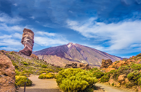
Tenerife is the largest of the Canary Islands, with an area of 1,920 km² and 342 kilometres of coastline. It is a very mountainous island, roughly triangular in shape, slightly elongated towards the north-east, and home to Mount Teide, which, at 3,718 m, is the highest peak in the whole of Spain.
It is the island with the most complex geology; its most recent volcanic eruption, that of Chinyero, took place in 1909. It boasts landscapes full of character, such as the geological complex of the Las Cañadas caldera and its stratovolcano, Mount Teide, which together form the third-highest and most voluminous volcanic structure on the planet, the Anaga and Teno massifs, Mount La Esperanza, the La Orotava Valley, and the great Cordillera Dorsal mountain range, which runs through almost the entire centre of the island and is covered in vast pine forests.

Thanks to its favourable climate throughout most of the year, Tenerife is known as the ‘island of eternal spring’. Among its many protected natural areas, the Teide National Park stands out as one of the world’s most visited national parks and has been designated a UNESCO World Heritage Site. Other natural areas of great ecological value also stand out, such as the Corona Forestal Natural Park and the Anaga and Teno Rural Parks. Both are incredibly beautiful and boast a wide variety of flora, with the Anaga Massif being home to the largest number of endemic plant species in the whole of Europe.
More...
Gran Canaria
The island of Gran Canaria is almost circular in shape, with a mountain range at its centre, and is situated almost in the centre of the Canary Islands archipelago. It has an area of 1,530 km², 256 kilometres of coastline and a maximum altitude of 1,949 m, reached at Pico de las Nieves.
Its terrain is very mountainous, with numerous ravines radiating out from the Caldera de Tejeda, which is dominated by the Roque Nublo and the Roque Bentayga. Apart from a few isolated stretches, the coastline is characterised by continuous cliffs in the north-western sector, reaching heights of over 500 metres. The ‘Andén Verde’, situated in the west of the island, reaches an altitude of 1,000 metres above sea level and was formed when a large section of the island slid into the ocean, giving this area its distinctive concave shape. In the south-eastern sector, the coastline is low-lying and beaches predominate.

Gran Canaria boasts a wide variety of climates, due both to the altitude gradient and to the effect of the trade winds, which give rise to marked differences in landscape between the windward and leeward sides. This results in a great number of microclimates and landscapes within the island itself, which is why it is known as a ‘miniature continent’.
Gran Canaria has a large number of Protected Natural Areas, including the Nublo Rural Park, the Doramas Forest, the Azuaje Ravine, Tamadaba, Pino Santo and the Inagua pine forest. In 2005, a large part of the island of Gran Canaria was designated a World Biosphere Reserve by UNESCO.
More...
Fuerteventura
Fuerteventura is an elongated island, with an area of 1,690 km² and 304 kilometres of coastline, making it the second-largest island in the archipelago. Its highest point is Pico de La Zarza (807 m), and it is one of the flattest islands in the Canary Islands archipelago. It lies very close to the island of Lanzarote, from which it is separated to the north by the Strait of La Bocaina and a small islet called Isla de Lobos.

Its landscape consists of extensive plains, the result of intense erosion over the course of its history, as it is the oldest island in the archipelago, estimated to be around 20 million years old. The Jandía Peninsula is the most prominent feature of its topography: an ancient, narrow and relatively high massif which features the island’s steepest cliffs. To the west lies the Punta Jandía plain, which connects to the rest of the island via the La Pared isthmus and is home to extensive dune fields.
The island’s flora is not abundant, despite the presence of a large number of endemic species, due to the peculiarities of the climate, which is almost desert-like, with scarce rainfall throughout the year. Despite this, it boasts numerous natural areas, and in 1999 the entire island was designated a World Biosphere Reserve by UNESCO.
More...
Lanzarote
Lanzarote is a very volcanic and fairly flat island situated at the eastern end of the archipelago. It is oblong in shape, with an area of 845 km², 191 kilometres of coastline and a maximum altitude of 670 metres, reached at the Peñas de Chache. Nearby, at the northern tip of the island, there are several islets, such as La Graciosa, Montaña Clara and Alegranza.

Most of the island consists of young volcanic cones, except for the northern tip, where the Famara and Ajaches massifs are located. Between these two massifs lies a vast volcanic field centred on the great Timanfaya volcano, whose most significant eruption took place relatively recently: between September 1730 and April 1736. This eruption gave rise to the present-day cones of Timanfaya and Pico Partido, and the so-called Mountains of Fire: a series of clustered cones that still bear traces of volcanic activity.
Between Timanfaya and the Ajaches lies La Geria, an area renowned for the uniqueness of its volcanic landscape, which for centuries has been used by people to plant vines that produce an exceptional wine. Here, the vines are planted directly into fields of volcanic lapilli, sheltered by small circular dry-stone walls that protect them from the wind.
Lanzarote’s landscape and natural environment are so special that, in 1993, the entire island was designated a UNESCO World Biosphere Reserve.
More...


Canariavision
Visual Guide to the Canary Islands
Visualcuba
 Visual Guide to Cuba
Camaravision
 Digital Art Photography