

Geology
Geologically, the Canary
Islands consist of a series of separate volcanic elevations rising from a
depth of over 4,000 metres, situated on a transition zone within the oceanic
crust, and estimated to be between 150 and 180 million years old,
corresponding to the early stages of the opening of the Atlantic Ocean.
The oldest islands are the eastern ones, Lanzarote and Fuerteventura, which
emerged some 16–22 million years ago, followed by the central islands, Gran
Canaria, Tenerife and La Gomera, which are between 8.5 and 14.5 million
years old. The youngest islands are La Palma, estimated to be around 2
million years old, and El Hierro, around 1.1 million years old. As a result
of this significant difference in age, the eastern islands are heavily
eroded, featuring vast plains formed by material resulting from the gradual
dismantling of ancient volcanic structures. The central islands, where this
process has not yet had time to take place, are very mountainous, with an
abundance of deep valleys and ravines. On La Palma and El Hierro, their
geological youth is clearly evident from the presence of hundreds of
volcanic cones, which show that these islands are still actively forming;
the clearest evidence of this process is the three volcanoes that have
emerged over the last 100 years on the island of La Palma, in 1949, 1971 and
2021.

Origin of the Canary Islands
There are three main theories regarding their
origin, the most widely accepted of which for a long time was the ‘hotspot’
theory, which posits that the Canary Islands have gradually emerged from a
thermal plume originating at the base of the Earth’s mantle, which is
believed to be the source of all the magma in the archipelago. As this plume
is fixed in position relative to the African plate, which is moving from
west to east, over time a group of islands would have formed in that same
direction.
However, two alternative hypotheses have
emerged in recent times. One is the ‘propagating fracture’ hypothesis, which
links the origin of the islands to the successive east-to-west propagation
of the Atlas Mountains in North Africa. The other hypothesis—and the one
currently most widely accepted within the scientific community—links the
origin of each island to reverse faults occurring in the Earth’s crust,
resulting in blocks rising from the ocean floor as they collide with the
African continent, which in turn leads to a progressive series of magma
eruptions.

Volcanology
Regardless of its origin, the fact remains that the
Canary Islands are the result of a succession of volcanic eruptions on the
seabed, which have gradually formed each of the islands as the volcanic
structure rose above the sea surface. Successive eruptions over thousands or
millions of years have built upon one another, so that the islands’ landmass
has gradually increased in both area and height.
Magma
can be expelled in three different forms: in a liquid state, as lava flows
of varying thickness; in a solid state, as pyroclastic material, lapilli and
ash; or in a gaseous state. In the Canary Islands, the first two forms
predominate, and they often combine or alternate within a single eruption.
Pyroclastic materials, such as lapilli or picón, and ash, are very common
across all the islands of the Canary Islands archipelago, usually forming
small volcanic cones throughout the territory.
Basaltic lava flows are also very common, and usually produce an extremely
rough or even jagged surface, which is locally known as ‘malpaís’. As the
lava advances, the scoriaceous surface—which cools as it moves across the
ground—collapses at its leading edge, yet continues to advance due to the
pressure of the molten lava, which remains hot within the flow.

Over time, volcanic structures are subjected to erosive processes caused mainly by water, wind and waves, which cause the island’s relief to become progressively smoother and give rise to sedimentary formations, such as the extensive foothill and landslide deposits stretching along the entire northern coastline of Anaga, or the wind-blown sand deposits covering many areas of Lanzarote and Fuerteventura.
Volcanic tubes
Among the wide variety of volcanic structures in
the Canary Islands, the formation of volcanic channels and tubes stands out.
These are associated with effusive eruptions and are formed when a lava flow
moving down a slope cools on contact with the air, causing both the
outermost surface and the area in contact with the ground to begin to
solidify, whilst the lava continues to flow between the two solidified
layers. If the slope is steep, the lava channel will usually be left empty
once volcanic activity ceases, giving rise to the well-known volcanic tubes
or caves.
These magnificent volcanic formations
usually remain hidden until, for whatever reason, the upper layer breaks
away, forming a ‘jameo’ – that is, a hollow in the ground that exposes the
interior of the volcanic tube – as is the case with the Jameos del Agua in
Lanzarote. Other examples, renowned for their spectacular nature and length,
include the volcanic tubes of the Corona volcano and the Cueva de Los Verdes
in Lanzarote, or the Cueva del Viento in Tenerife.

The Story of a Volcano
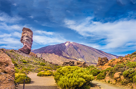
Volcanic phenomena are extremely powerful and striking, and have always captured the attention of scientists, historians and chroniclers, as well as all those who have had the good fortune – or misfortune – to experience them.This is how a chronicler of the time, in the late 18th century, described the eruption of the Chahorra Volcano, also known as Las Narices del Teide, which lasted from 9 June to 15 September 1798.
"At around ten o’clock in the evening on 9 June 1798, the villages on the southern side of Tenerife – particularly those in the Guía and Chío areas, which are closest to Las Cañadas – heard a loud explosion and observed that the Chahorra mountain, adjacent to Pico del Teide, was spewing flames and volcanic material. These eruptions, accompanied by a noise that spread terror across the entire island, lasted for three days. Very shortly afterwards, another crater opened at the summit of the mountain, a mile from the first, weakening the activity of the latter, which also spewed forth torrents of lava. Not far from this crater, a third one opened up, with explosions occurring in rapid succession. Finally, a fourth fissure released whirlwinds of smoke and burning rocks...".


Canariavision
Visual Guide to the Canary Islands
Visualcuba
 Visual Guide to Cuba
Camaravision
 Digital Art Photography