

Vegetation zones
One of the main
characteristics of the Canary Islands’ flora is its distribution across
altitudinal zones, known as vegetation zones, due chiefly to climatic
conditions, variations in rainfall and temperature – which are closely
linked to the greater or lesser influence of the trade winds, the
orientation of the terrain, and, above all, the altitudinal profile of each
of the islands. These zones are arranged as if they were strata superimposed
one upon the other, from sea level to the summits of the mountains; they are
more varied on the central and western islands, owing to their greater
altitude and more diverse topography, and less so on the eastern islands due
to their limited elevation and higher degree of geological erosion.
The characteristics of the vegetation landscape in each of these vegetation
zones vary according to the dominant species found in each, which in turn
give their names to the most typical vegetation formations of the Canary
Islands’ landscape: cardonales, tabaibales, sabinares, pinares, codesares,
etc.
The first scientist to
classify the flora of the Canary Islands into altitudinal zones was the
eminent German naturalist Alexander von Humboldt, when he visited the island
of Tenerife in 1799. During his ascent of Mount Teide, setting off from
Puerto de la Cruz, he took careful note of the vegetation he encountered as
he climbed towards the island’s highest peak. His observations were later
recorded in his *Tableau physique des Iles Canaries. Géographie des Plantes
du Pic de Tenerife*, one of the most notable works in the history of
Canarian botany. In it, Humboldt identified five vegetation zones on
Tenerife, stretching from sea level to the summit of El Teide, which he
named the Vine Zone, the Laurel Zone, the Pine Zone, the Broom Zone and the
Grass Zone.
Over time, this primitive
classification has been modified and expanded as science has advanced and
different models have been proposed, although the scientists who have
studied this subject most extensively have not yet reached full agreement on
the number of zones or their names.
Leaving aside specialised scientific
debates, one of the most widely accepted and recognised classifications
today is the one that identifies six vegetation zones, which, proceeding
from the coast towards the summit, are: the infracanarian zone, the dry
thermocanarian zone, the humid thermocanarian zone, the mesocanarian zone,
the supracanarian zone and the orocanarian zone.
The infracanarian zone

The infracanarian zone,
also known as the lower or basal zone, covers the area between 0 and 400
metres in altitude, although this varies from place to place depending on
the orientation of the terrain and the degree of exposure to the trade
winds. It has a desert or semi-desert character, bearing a strong
resemblance to the coastal areas of the former Spanish Sahara and
Mauritania, with low rainfall, high temperatures throughout most of the year
and a high level of daytime sunshine.
These climatic conditions, together
with the presence of rugged and eroded substrates, are what the species
living in these environments must endure; they are found in the coastal
areas of the southern slopes of all the islands, being particularly
widespread on Lanzarote and Fuerteventura.
Two plants
dominate this vegetation zone: the cardón (Euphorbia canariensis), which
forms a plant community known as a ‘cardonal’, and the tabaiba (Euphorbia
balsamífera ssp. balsamifera), which has its own community known as a
‘tabaibal’, although in many cases both coexist and share numerous
accompanying species: herbaceous plants and small xerophytic shrubs which,
to adapt to the drought, have developed numerous mechanisms such as fleshy
stems, spiny leaves, very long shallow roots, etc.tc.
Many of these species are Canarian endemics that are highly characteristic
of this extreme environment, such as the bejeques (Aeonium lindleyi, Aeonium
holochrysum, Aeonium percarneum…), the cardoncillos (Ceropegia fusca,
Ceropegia dichotoma), the verode (Kleinia neriifolia), the leña buena
(Cneorum pulverulentum), etc.
Dry thermocanarian zone

The dry Thermocanarian
zone, or juniper-palm forest zone, occupies a narrow strip situated at an
altitude of approximately 200–500 metres, mainly on north- and east-facing
slopes, and is almost entirely absent from the south and south-west-facing
slopes.
Climatically, it is characterised by temperate
temperatures and moderate rainfall (an annual average of 15–18 °C and
350–600 mm of rainfall per year). The influence of the trade winds and the
proximity to areas where sea clouds form result in a gradual decrease in
sunshine levels and a slight increase in ambient humidity.
In ancient times, this vegetation zone was abundant and extended across all
the islands, particularly the central and western ones; however, following
the arrival of the first settlers in the Canary Islands – and especially
after the Conquest of the Islands – it was severely altered by the intensive
use of its land and resources, with the result that today it has almost
entirely disappeared in its original state.
Its
vegetation is characterised by the presence of large trees that are very
typical of the Canary Islands, such as the Canary Island palm (Phoenix
canariensis), which grows in valleys, ravines and on steep slopes, sometimes
forming small groves known as ‘palmerales’; the Canary Island juniper
(Juniperus canariensis), of which small groves such as El Sabinar on the
island of El Hierro still survive; and the dragon tree (Dracaena draco), a
legendary species of great beauty and the principal botanical symbol of the
Canary Islands.
Alongside these is a rich array of
shrubs and herbaceous plants, such as the Atlantic pistachio (Pistacia
atlantica), the mastic tree (Pistacia lentiscus), the willow (Salix
canariensis), the Maytenus (Maytenus canariensis), the orobal (Withania
aristata), the sage (Salvia canariensis), the gamona (Asphodelus ramosus),
the juagarzo (Cistus monspeliensis), the hierbamora (Bosea yervamora), etc.,
which together form one of the richest plant communities in our archipelago.
Humid thermocanarian zone

The humid Thermocanarian
climate, also known as the sub-humid Thermocanarian climate, is found
exclusively on a strip along the northern slopes of the highest islands, at
altitudes of between 400 and 1,200 metres, an area frequently swept by the
so-called ‘sea of clouds’, which forms when moisture-laden trade winds
collide with the terrain. This results in a climate characterised by low
levels of sunshine, an average temperature of around 14°C, annual rainfall
of approximately 800–1,400 mm, and high levels of humidity within the
forests that grow in this zone.
The vegetation is very
well adapted to the trade wind mists, the moisture from which condenses on
contact with the leaves of the large trees that make up these forests,
producing the phenomenon of horizontal rain, which creates an almost
permanently humid environment.
This area is home
to two types of forest that are very different from the rest of the
vegetation found in the Canary Islands: the laurel forest and the
fayal-brezal. Laurel forests are found in only a few regions of the world,
and the Canary Islands are home to the most authentic and best-preserved
examples. This type of vegetation is a remnant of the Mediterranean forests
of the Tertiary period, characterised by the presence of large trees with
lanceolate, leathery and glossy leaves, adapted to the warm, humid
environment that forms beneath the almost permanent mists of the sea of
clouds.
The laurel forest forms a dense canopy
made up of the crowns of some twenty species of large trees, including the
laurel (Laurus novocanariensis), the barbusano (Apollonias barbujana), the
viñátigo (Persea indica), the palo blanco (Picconia excelsa) and the tilo
(Ocotea foetens). This tree canopy allows very little light to reach the
lower strata, resulting in sparse undergrowth consisting mainly of small
shrubs, ferns, lichens and mosses.
In degraded areas
of the laurel forest, or in locations more exposed to the wind and where
humidity is lower, the Fayal-heath forest develops; this is a more open
forest type with a poorer variety of tree species, dominated by faya
(Morella faya), heather (Erica arborea) and, to a lesser extent, Canary
Island holly (Ilex canariensis) and laurel (Laurus novocanariensis),
accompanied by numerous herbaceous and shrubby species.
Mesocanarian zone

The Mesocanarian zone, also
known as the dry montane zone, lies at an altitude of between 1,200 and
2,000 metres, situated above the humid Thermocanarian zone on the northern
slopes and above the Infracanarian zone on the southern-facing slopes. The
climate of this area is characterised by cold winters and very hot summers;
the prevailing winds are dry; average annual temperatures are around 15°C;
and rainfall is scarce, at around 300–500 mm per year, occurring mainly in
autumn and winter, and falling as snow at higher altitudes.
The vegetation consists of large forests of Canary Island pine (Pinus
canariensis), a large, fast-growing tree with highly prized timber, which
also possesses a high resistance to fire. Its undergrowth is very sparse,
with shrub species such as the codeso (Adenocarpus foliolosus), the broom
(Chamaecytisus proliferus), the rockrose (Cistus symphytifolius), wild thyme
(Micromeria benthamii), mountain pennyroyal (Bystropogon origanifolius), the
pine forest clover (Lotus campylocladus), etc.
This forest type is only well represented on the islands of Tenerife, Gran
Canaria, La Palma and El Hierro; the main Canarian pine forests are those of
Vilaflor, Icod and La Esperanza in Tenerife; those of Caldera de Taburiente,
Fuencaliente and Puntagorda in La Palma; and those of Tamadaba, Pajonales
and Inagua in Gran Canaria; and El Pinar in El Hierro.
On north-facing slopes, where the pine forests meet areas of humid woodland,
a type of forest known as a mixed pine forest occasionally forms, in which
pines intermingle with shrubby elements typical of the Fayal-brezal habitat:
faya (Morella faya), heather (Erica arborea), holly (Ilex canariensis), etc.
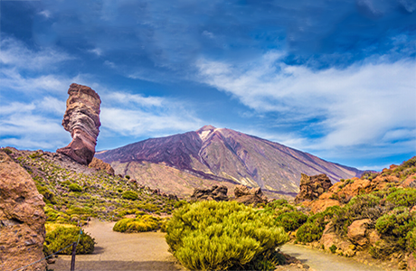
Supracanarian zone

The Supracanarian
zone lies at an altitude of over 2,000 metres and is found only on Tenerife
and La Palma, as these are the highest islands in the Canary Islands
archipelago. The climate is dry and characterised by wide temperature
fluctuations, with hot summers and very cold winters, during which snowfall
and severe frosts occur. Rainfall is low, averaging between 350 and 450 mm
per year, and is concentrated in the autumn and winter months. Humidity
rarely exceeds 50 per cent, and there is a high level of sunshine due to the
altitude and the large number of clear days throughout the year.
The
vegetation consists almost entirely of scrub, with few trees; this scrub is
more or less open and takes on a stocky or cushion-like form, creating an
interior environment where the temperature and humidity conditions mitigate
the dryness of the air, the irregularity of rainfall and the high levels of
sunshine during the day.
The dominant species in
the high-mountain scrubland are broom and codeso. In Tenerife, the Teide
broom (Spartocytisus supranubius) predominates, whilst in La Palma it is the
summit codeso (Adenocarpus viscosus). These plants are accompanied by a
large number of local endemic species, some of which are very beautiful and
emblematic of the Canary Islands’ flora, such as the red tajinaste of El
Teide (Echium wildpretii), and others such as the summit pansy (Viola
palmensis), the Cañadas rockrose (Cistus osbaeckiaefolius), or the La Palma
summit broom (Genista benehoavensis), all of which are threatened or at risk
of extinction.
Orocanarian zone

The Orocanario zone lies at
an altitude of over 3,100 metres and is found only on the summits of Mount
Teide, on the island of Tenerife, which are almost devoid of vegetation.
The soil is very poor and rocky, and the climate is relatively cold, with
predominantly dry south-westerly winds and annual rainfall of less than 400
mm, generally in the form of snow, resulting in very dry summers and long,
harsh winters.
In this zone there are no trees or
shrubs, and only a few small herbaceous plants grow, which are endemic to
this area and of great scientific interest, such as the small and pretty
Teide violet (Viola cheiranthifolia), which also thrives amongst certain
rocks in the lower areas of Mount Teide, the silver thistle (Stemmacantha
cynaroides), the Teide campion (Silene nocteolens), and the Teide laphangium
(Laphangium teydeum).
Coastal vegetation

In the Canary Islands,
halophilic communities form a narrow coastal belt very close to sea level
and are influenced by the high salinity in the environment, resulting from
the sea breeze. Climatically, this strip is characterised by low rainfall
(100–300 mm per year), very high average temperatures and high levels of
sunshine throughout the year.
Under these conditions,
many plants have had to develop various mechanisms to adapt to the
environment and ensure their survival. The most notable of these are
succulence (thickening of the stems), hairiness (a hairy covering on leaves
and stems), the absence of leaves or their rapid shedding, and the presence
of salt glands to expel excess salt.
The most
representative examples of this type of vegetation can be found in areas
such as the dunes of Maspalomas, Tufia and Arinaga on Gran Canaria; the
dunes of Corralejo; the beaches of Sotavento and Morro Jable on
Fuerteventura; the beaches of El Médano on Tenerife; the south-eastern coast
of Lanzarote; and the islet of La Graciosa.
Among the
most common species found in these areas are the sea grape (Tetraena
fontanesii), sea lavender (Limonium imbricatum, Limonium pectinatum…), sea
lettuce (Astydamia latifolia), sea heather (Frankeia ericifolia), the
tabaibilla (Euphorbia aphylla), sea parsley (Crithmum maritimum), sea
hawthorn (Lycium intricatum), the salado (Schizogyne sericea), etc.
Rock-dwelling vegetation

The Canary Islands’ landscape features a highly
diverse topography, in which the vertical element plays a prominent role,
with the presence of numerous cliffs, precipices, escarpments and steep
slopes, characterised by a highly fractured and fissured surface, upon which
a special type of vegetation known as rupicolous or fissure-dwelling
vegetation grows. The abundance of erosional basins on all slopes and at
different altitudes, as well as the microclimatic diversity of the
archipelago, allows for a very high level of floristic diversity within this
type of vegetation, despite the difficulty of colonising areas characterised
by steep slopes.
Furthermore, these environments
often support plants which, whilst not native to the area, found a safe
haven there in the past from the pressure exerted by livestock. Ecological
conditions, particularly humidity and temperature, favour the greater
prevalence of rock-dwelling plant communities in north- and
north-east-facing areas; and although they extend from the coast to the
mountain peaks, they thrive best in the humid environments of the
mid-altitude zones.
Among the numerous species that
could be cited as being particularly well-adapted to the rock habitats of
the Canary Islands are the ‘bejeques’ or ‘veroles’ (Aeonium canariense,
Aeonium sedifolium, Aeonium decorum, Aeonium ciliatum…), the ‘cerrajas’
(Sonchus hierrensis, Sonchus radicatus, Sonchus tectifolius...), the
chahorras (Sideritis nutans, Sideritis gomerae...), the amargosa (Vieria
laevigata), the Anaga sage (Salvia broussonetii), the cliff thistle (Carlina
canariensis), etc.


Canariavision
Visual Guide to the Canary Islands
Visualcuba
 Visual Guide to Cuba
Camaravision
 Digital Art Photography