

The topography of
the Canary Islands is the result of the ongoing process of creation and
destruction of the volcanic materials that form the islands. The creation of
the topography is caused by the successive volcanic eruptions that have
taken place throughout the archipelago’s geological history, whilst its
destruction is caused by various erosive processes: water, snow, winds,
tides, landslides or implosions, etc.
This has given
rise to a highly diverse landscape, in which each of the islands has a
distinct and unique appearance, which depends directly on its past volcanic
activity, its geological age, and the resistance of its materials to
erosion.
All the islands, except Lanzarote
and Fuerteventura, reach their highest points in the central areas, and the
terrain slopes downwards from there towards the coast. From these higher
areas, steep slopes descend, accompanied by deep ravines that reach down to
the sea. This topographical layout, together with the characteristics
inherent in being an archipelago situated in the Atlantic Ocean off the
coast of Africa, gives rise to a unique and exceptionally beautiful
landscape, with a wide variety of soils, climates and vegetation.
The predominance of this mountainous terrain also has a significant
influence on the atmospheric dynamics of the Canary Islands, as the highest
mountainous areas act as a veritable barrier to air masses; when these
collide with them, they are forced to rise, causing them to cool, condense
and release moisture on the north-facing slopes, which are exposed to the
wind. Consequently, the mountainous islands are more humid than the flat
ones, and, within the mountainous islands, the north-facing slopes are more
humid than those facing south, which has a significant influence on the
islands’ vegetation.

Types of landform
Among the wide variety of landforms found in the
Canary Islands, the most notable are as follows:
Ancient massifs.
The oldest parts are known as ancient massifs, which are the result of the
most primitive volcanic processes on each island. These landforms are found
in Gran Canaria, La Gomera, the south of Fuerteventura, the north of La
Palma, and certain areas of Tenerife and Lanzarote. They generally form the
backbone of most of the islands, comprising vast volumes of material that
have accumulated to considerable heights, and are criss-crossed by a dense
network of dikes and ravines.
The main examples of
this landform are the Famara and Los Ajaches massifs in Lanzarote, the
Betancuria massif in Fuerteventura, the Tamadaba, Güigüí and
Inagua-Pajonales massifs in Gran Canaria, the Teno, Anaga and Adeje massifs
in Tenerife, the northern half of the island of La Palma, and the entire
island of La Gomera. The only island that does not feature this type of
terrain is El Hierro, the youngest in the Canary Islands, where not enough
time has yet passed for water to have had such a significant impact on the
landscape.
Ridge systems. Ridge systems are imposing volcanic
structures formed by the accumulation of lava emitted along the
archipelago’s main structural lines. They play a fundamental role in the
development and configuration of the islands, and are key triggers of the
massive gravitational landslides that will give rise to the large valleys
and calderas.
Most historical eruptions have been
concentrated along these ridges, and the same will be true of future
eruptions. This recent eruptive activity – the last few thousand years in
geological terms – can be clearly observed on the Cumbre Vieja ridge on the
island of La Palma, which has been formed by the successive aggregation of
elongated mountain ridges that slope down towards the sea on either side of
the volcanic chain.

The most prominent ridges in the Canary Islands are the
Cumbre Vieja ridge, to the south of the island of La Palma, and the La
Esperanza ridge, also known as the Pedro Gil ridge, on Tenerife.
The ridges of La Palma and El Hierro extend out into the sea, suggesting
that, in the geological future, these islands will develop much further.
Valleys and calderas. Valleys and calderas are important
and characteristic features of the Canary Islands’ landscape, and their
origins and formation are varied.
The most significant
valleys are believed to have been formed by large gravitational landslides;
the most notable formations of this type are the La Orotava and Güímar
valleys on the island of Tenerife, the El Golfo and Las Playas valleys on El
Hierro, and the Aridane Valley on the island of La Palma.
On the older islands, such as Lanzarote and Fuerteventura, where erosion
processes are well advanced, the valleys have very open shapes and flat
bottoms; the headwaters have disappeared, giving way to inland plains that
connect one valley to another, with no topographical features to separate
them. These are more or less levelled landscapes, without steep gradients
and with an abundance of sedimentary deposits.

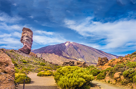
Calderas also exhibit a variety of formation processes. In Tenerife, the Caldera de Las Cañadas is particularly noteworthy; it is actually two joined semi-calderas formed by two distinct major gravitational landslides. The other major structure of this type in the Canary Islands is the Caldera de Taburiente, on La Palma, which occupies roughly the central part of the island and was formed by a combination of volcanic processes, gravitational landslides and severe erosion caused by surface runoff.
Coasts. The Canary Islands’ coasts
take on different forms due to the constant process of marine erosion to
which they are subjected. Their shapes are highly varied, and generally
consist of imposing cliffs, lava slopes that reach down to the sea forming
low-lying islands, rocky coastal strips, or large beaches of black or yellow
sand. High coastlines with steep, rocky terrain, formed by cliffs,
predominate, and there are very few areas of sediment accumulation, which
means there are very few natural beaches.
However, on
the eastern islands, low-lying coasts are common, consisting of low-lying
areas where yellow sandy beaches predominate due to the direct supply of
sand carried by the south-easterly winds from the African continent. The
most notable of these are Papagayo and Mujeres on Lanzarote, Corralejo and
Jandía on Fuerteventura, and Las Canteras or Playa del Inglés on Gran
Canaria.

Gorges. Gorges are one of the most
common landforms in the archipelago. They are very narrow, deep valleys
wedged between steep mountain walls. They are short in length and generally
have a very distinct straight profile, and the riverbed is covered with
debris carried by the water.
They were formed by torrential waters which
eroded and dismantled the volcanic landforms during a bygone era
characterised by abundant and regular rainfall.
The ravines are found in
the ancient massifs, which have been most affected by erosion, such as
Anaga, Teno and Adeje on Tenerife; the northern part of La Palma; the west
of Gran Canaria; and almost the whole of La Gomera.
Recent volcanoes. One of the most distinctive features of
the Canary Islands’ landscape is its recent volcanic formations. The
youngest materials are the most spectacular, as they are the most visible –
not yet covered by vegetation – and were formed by historical eruptions that
affected some of the islands in the not-too-distant past.
They overlie
previously formed structures and, in many cases, have reached the sea,
increasing the islands’ land area. Notable examples include the historic
eruptions at Timanfaya, which took place on the island of Lanzarote between
1730 and 1736, and the most recent volcanoes on the island of La Palma, such
as San Juan and Teneguía.

Coastal rocks. Sea stacks are a common feature along the
Canary Islands’ coastlines, formed as a result of the retreat of the former
shoreline due to intense erosion. They remain as upright remnants that were
not eroded, thanks to the resistance these materials offered against the
waves.
The best known for their visual appeal are the
Roques de Salmor and the Roque de Bonanza on El Hierro, the Roques de Anaga
and the Roque de Garachico on Tenerife, and the Roque de Gando on Gran
Canaria.

Natural regions. Depending on the topography,
altitude and aspect in question – and particularly on the islands with the
most rugged terrain or greatest altitude – we may find natural regions that
encompass summit, mid-altitude or coastal areas, and even continuous areas
that include several of these spaces or zones, and the varying degrees of
slope within each area give rise to a wide variety of microclimates,
resulting in different types of landscape within the same region.
It is important to note that the size and
boundaries of the regions are determined by the topography and geology of
each island – some of which have very recent and active volcanic activity –
as well as other biological and environmental factors, in the case of the
landmass, and the slope, seabed type, marine currents and temperature, in
the case of the island shelf.
On islands such as La Gomera and Gran Canaria, this results in radial
regions due to the ravines that largely characterise their distinctive
relief. On Tenerife and La Palma, two high islands with ridge-shaped
peaks—one running perpendicular to and the other parallel to the direction
of the trade winds—natural regions form on both sides of the ridges, in
addition to those on the peaks themselves, extending from these peaks down
to the coast. El Hierro exhibits a similar pattern, although less varied due
to its status as a young island that formed rapidly. Lanzarote and
Fuerteventura have a lower diversity of regions, as well as larger ones,
logically due to their gentle topography and low elevation.
Consequently, alongside
large natural units, there are also small habitats which, in many cases, are
home to unique and extremely unstable ecosystems, as well as local endemic
species of great biological importance.


Canariavision
Visual Guide to the Canary Islands
Visualcuba
 Visual Guide to Cuba
Camaravision
 Digital Art Photography