

Tenerife
Tenerife is a largely rugged island, its
landscape shaped by successive volcanic eruptions throughout history, the
most recent of which was that of El Chinyero in 1909.The island is situated between latitudes 28° and 29° N and longitudes 16° and 17° W, slightly north of the Tropic of Cancer, occupying a central position between Gran Canaria, La Gomera and La Palma. It lies just over 300 km from the African continent and around 1,000 km from the Iberian Peninsula.
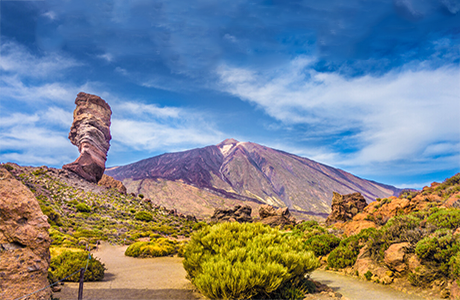
With its triangular shape, Tenerife is the largest island in the Canary Islands archipelago, with an area of 2,034.38 km². It also has the longest coastline, stretching 342 kilometres. Tenerife is the highest island in Spain and the tenth highest island in the world: at its centre rises Mount Teide, which, at 3,718 m above sea level, is the highest point in Spain, the highest point on any of the islands in the Atlantic Ocean, and the third-largest volcano in the world when measured from its base on the ocean floor.
The island’s rugged terrain and varied climates give rise to a landscape of many different forms and features, ranging from Teide National Park, with its amalgam of colours resulting from successive volcanic eruptions, to the cliffs of Los Gigantes with their vertical walls, via semi-desert areas with drought-resistant plants in the south, or purely volcanic environments such as the Malpaís de Güímar or the Malpaís de La Rasca.
It also boasts natural beaches such as El Médano, valleys with tropical and subtropical crops, wooded laurel forest landscapes in the Anaga and Teno massifs, and extensive pine forests above this latter vegetation zone.

El Teide

Playa de las Teresitas

Anaga

Arco de Tajao

Playa de la Tejita

Masca

Montañas de Anaga


Canariavision
Visual Guide to the Canary Islands
Visualcuba
 Visual Guide to Cuba
Camaravision
 Digital Art Photography